|
REPORTS / AFTER ACTION - MOST RECENT - BELOW: below are summaries of
Radio Reporting Activities. Such are generally after action. If
you want to listen to the SER Team on your uv5r ... contact Nathan 530-474-3267
for radio programming and updates (including Cal Fire, etc for
monitoring). This is all Volunteer. The SER plan is exclusively
for Emergency Radio Communications. For 55 / 57 Tests / Exercises: Control Operator at
Control Point.
|
|
2026 06 18 SER PLAN DEACTIVATED
Thank you to all of you who have helped out
over the years.
At this time the SER Plan is DEACTIVATED.
Nathan K6PDS
|
|
2026 06 17 and continuing until further notice: Due to complaint by
apparently a local "ham",
Non Ham drill emergency practice exercises on the repeater is on hold at this
time. It is to be remembered that during all
such drills the Repeater Control Operator has been at the Control
Point pursuant to FCC regulations. It is the position of SER that
all such drills have been in accordance with FCC regulations,
proper, and essential for emergency communications preparedness
for life threatening wildfires, mobile evacuations, etc... .
Apparently the local Hams (not involved with the SER Plan) don't
read the rules, have no concern about the safety of those in
Shingletown or the high fire danger we are under. They have
no emergency communications plan and conduct no exercises or
drills. They merely use their repeaters for social talk and what
some may opine as - "meaningless drivel". Planned
SER practice
for mobile evacuation from wildfire is suspended on repeater (the
practice sessions would have been for about 8 minutes). Non Hams,
as per SER procedures, are to only the repeater for immediate safety of human life and immediate protection of
property... . Testing of propagation and matters related to
emergency communications during evacuation to save life of
Shingletown residents is adversely impacted. We only have a couple
of Hams who participate and the probability of 2 being present for
an emergency is very low (just a fact of life). I appreciate all
of those who have helped. We just got the plan back on track after
the repeater attack with almost every station having their radios
updated. The Plan is at least on "idle" in the
event of a fire (i.e., your radios and a plan are already in place
and at the ready for use in case of a fire). Everyone must
continue to monitor 24/7. Without practice, efficiency will be lost. Most
hams don't even begin to approach the level of efficiency and
professionalism you SER Team members have achieved.
IN MY POST TO THE AFTER ACTION PAGE, THE
QUESTION IS PRESENTED: "HAS HAM RADIO OUTLIVED ITS USEFULNESS OF
BEING A "SERVICE TO THE PUBLIC" WITH RESPECT TO "PROVIDING EMERGENCY COMMUNICATIONS"?
2026 06
17 7
day recap. Over the last 7 days, Shingletown has had 5
tone outs with emergency responses for Fires.
DRAFT.
SUBJECT: WILDFIRE DEATH THREAT AND THE THE
WILLFUL AND WANTON FAILURE OF HAM RADIO; ARRL; AND THE
FCC.
IT IS SAD THAT HAM RADIO USES "EMERGENCY
COMMUNICATIONS" AS A MARKETING TOOL TO ATTRACT PEOPLE TO BECOME
HAM OPERATORS. WHILE A FUNDAMENTAL PURPOSE OF
AMATEUR RADIO IS TO BE A "SERVICE TO THE PUBLIC AS A
VOLUNTARY NONCOMMERCIAL COMMUNICATION SERVICE, PARTICULARLY
WITH RESPECT TO PROVIDING EMERGENCY COMMUNICATIONS",
SUCH OBJECTIVE IS ESSENTIALLY WITHOUT SUBSTANCE AND IS
INTENTIONALLY DESTROYED. PEOPLE WHO EXPRESS INTEREST IN
BECOMING AMATEUR RADIO OPERATORS EVENTUALLY WALK AWAY BECAUSE OF
THE LACK OF SERIOUS EMERGENCY COMMUNICATIONS PRACTICE BY
HAMS.
IN SHINGLETOWN WE HAVE A COUPLE OF
HAMS WHO ACTUALLY WALK THE WALK. THANK YOU FOR YOUR SERVICE.
IN OTHER CASES, HAMS USE FREQUENCIES AND
EXPENSIVE EQUIPMENT FOR PURE SOCIAL MATTERS (E.G., TO
TALK ABOUT GARDENING, THE WEATHER, SEPTIC TANK PROBLEMS, A
"HOT LOOKING" LADY AT THE PIZZA PLACE, BACKED UP HOME
SEWER LINE, AND HOW A HAM DESCRIBED HIMSELF AS A
"DEVIOUS PERSON" AND WAS ABLE TO GET THE CABLE PROVIDER TO REPLACE A
CABLE AFTER HIS BURN PILE DESTROYED THE CABLE, ETC... ).
WELL, THAT MAY BE WHAT IS IMPORTANT TO SOME, AND MAY ACCOMPLISH SOME
PURPOSE. HOWEVER, THERE IS NO "EMERGENCY
COMMUNICATIONS" OR "SERVICE TO THE
PUBLIC". THERE IS NO CONCERN ABOUT THE COMMUNITY AND THE
THREAT WE FACE DAILY BY WILD FIRES. ON THIS POINT, WE HAVE HAD
SEVERAL DEATHS IN SHINGLETOWN DUE TO FIRES. ADDITIONALLY THERE
HAVE BEEN INJURIES.
SHINGLETOWN HAS HAD EVACUATIONS DUE TO WILD
FIRES. WE FACE ROUTINE POWER OUTAGES, LAND LINE FAILURES AND
INTERNET OUTAGES, AND CELL OUTAGES. NOT TOO LONG AGO
SHINGLETOWN WAS ON THE TOP OF CALIFORNIA'S BURN LIST FOR AREAS TO
BE DESTROYED BY WILD FIRE.
REMEMBER, MAUI? PARADISE? SOUTHERN
CALIFORNIA? THE ONLY QUESTION IS: WILL SHINGLETOWN BE
NEXT?
BUT DON'T WORRY, HAMS WHILE LOOKING OVER YOUR
BURNED OUT RUBBLE, DESTROYED HOMES, AND THE DEAD, WILL REGURGITATE
- "... BUT HAM GETS THROUGH WHEN ALL ELSE FAILS".
WELL, HAM RADIO HAS FAILED AND WILLFULLY CONTINUES TO DO
SO. BUREAUCRATS (in and out of government) MINDLESSLY
REGURGITATE "RULES" WITHOUT ANY ACTUAL THOUGHT PROCESS
OR REFLECTION ON THE PURPOSE OF THE LAW. THEY IGNORE A REAL
QUESTION WHICH MUST BE ASKED AND ANSWERED - WHAT PURPOSE DOES HAM
RADIO SERVE TO THE PUBLIC SAFETY? WHAT PURPOSE DOES IT SERVE TO
THE PUBLIC DURING WILDFIRE EVACUATIONS?
TO MAKE IT CLEAR, WE ARE FOCUSED ON WHEN THE FIRE IS
HERE. WE ARE NOT TALKING ABOUT "AFTER" THE FIRE AND
GETTING FOOD, WATER, HOUSING ETC... . SUCH ARE GOOD THINGS.
BUT, WE ARE TALKING ABOUT IMMEDIATE DEATH BY FIRE COMING TO
GET YOU. IT IS AT THIS VERY MOMENT THAT IT IS COMING FOR
YOU, YOUR FAMILY AND YOUR ENTIRE COMMUNITY AT 2:30 IN THE MORNING
WITH THE PHONE LINES AND INTERNET NOT WORKING AND THE POWER
OUT? WHAT COMMUNICATIONS PLAN HAVE
HAMS ACTUALLY PUT IN PLACE TO SAVE LIVES AT THAT INSTANT? A
FEW HAMS WHO TALK ON SOCIAL NETS WILL NOT CUT IT.
HAVING PEOPLE WHO HAVE NEVER PRACTICED WILL BE A DISASTER. SO,
WHAT PROCEDURES AND PRE-STAGED INFRASTRUCTURE (AND PEOPLE WHO ARE
ABLE TO COMMUNICATE EFFECTIVELY) AT THAT MOMENT HAVE HAMS
ESTABLISHED AND TRAINED? WHAT DRILL AND PRACTICE HAVE THEY ACTUALLY DONE
SO THAT LIFE SAVING INFORMATION (INCLUDING IMMEDIATE STATUS OF
ROADS BLOCKED BY FIRE) CAN BE SPREAD TO THEIR COMMUNITY TO SAVE LIVES AT THE MOMENT IT
MATTERS? SADLY THE FACT IS - THEY HAVE DONE NOTHING.
WORSE THAN THAT, THEY SEEK TO DESTROY ANY SUCH PLAN.
SO, THE FOLLOWING QUESTION IS
PRESENTED:
HAS HAM RADIO OUTLIVED ITS USEFULNESS OF
BEING A "SERVICE TO THE PUBLIC" WITH RESPECT TO "PROVIDING EMERGENCY COMMUNICATIONS"?
IMPROVEMENTS CAN BE MADE TO SAVE HAM
RADIO, BUT IT WILL TAKE LEADERSHIP, PEOPLE WITH VISION, AND
THE ABILITY TO 'THINK OUTSIDE THE BOX". EVEN HAVING
PEOPLE WITH AN ABILITY "THINK" AND POSSESS SOME LEVEL OF
COMMON SENSE WOULD BE A GOOD STARTING POINT. K6PDS
|
|
2026 06
17 (Wednesday) 0431 hours Cal Fire Tone out...
SER Silent Monitoring. 0434 at scene - out by
locals. 0435 SER Silent Monitoring deactivated
|
|
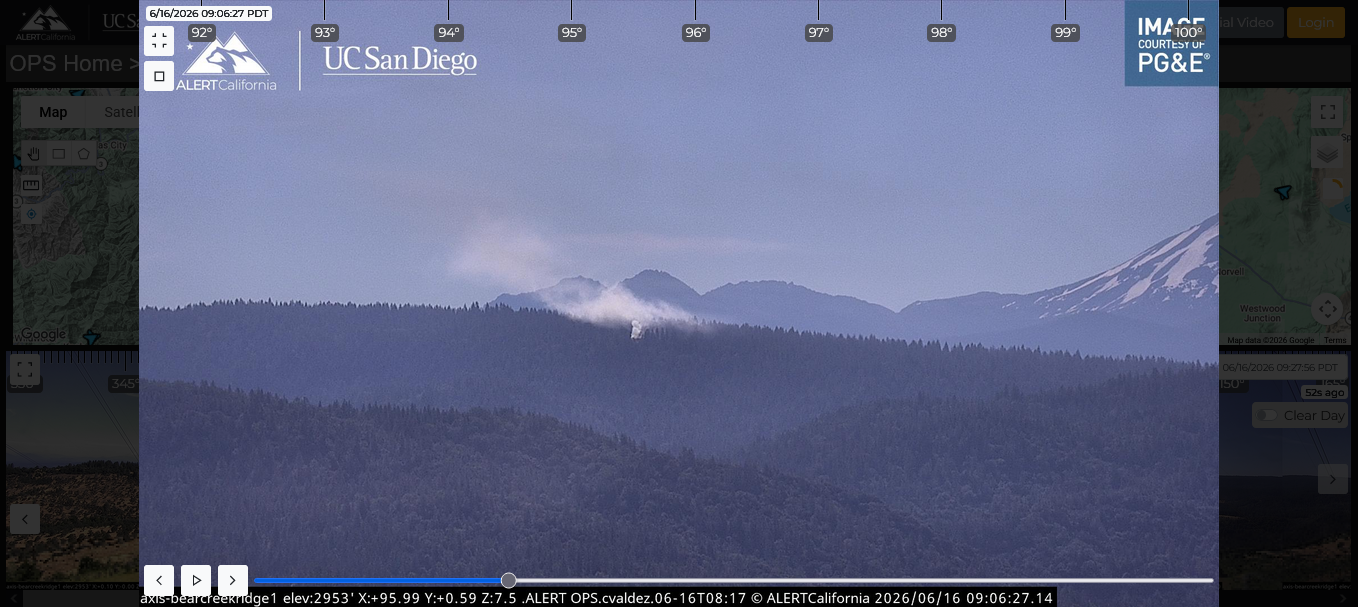
2026 06
16 (Tuesday) 0825 hours Cal Fire Tone Out - Creek Incident.
In Area of 100 and 600 Road...Cal Fire responding ... SER (PDS)
Smoke Col Visible Bear Creek Camera 95.49 Deg. T;
Round Mt Camera 159.90 Deg. T. In Area of T31 N
1E SW Quarter Section 11.... Internet Winds over
Incident out of West 2 mph ... NNW of Airport ... North of
Circle K area approx 2 miles ... Little under 4 miles North of MWM
(Rest Area) ... 0856 hours Cal Fire (E547 at scene) Logging
incident / have line around it ... continue 2463 and
Prevention 24... cancel balance. 0858 hours SER deactivate
Advisory. 0928 hours camera view - smoke almost totally
gone.
Stations Responding (on 63): i1 f14 BZL
g7 B1 F1 MWM (on 58).
|
|
2026 06 15 (Monday) 1631 Hours INFORMATION
- ON 59.
SER MONITORING / TRANSMIT PLAN UPDATE SCHEDULED FOR 1915 HOURS ON
59. Responses: F2
BZL F14 MW1. Plan e-mail to follow after 1915
hours.
|
|
2026 06 15 (Monday) 1024 Hours Random
TEST 59 no notice /
no activation / no tone out. Request: Any 1 station respond. Responses:
B1 S6
|
|
2026 06 14 (Sunday) 1629 Hours Random
TEST 59 no notice /
no activation / no tone out. Request: Any 1 station respond. Responses:
B1
|
|
THIS
WEEKS SHINGLETOWN FIRE RECAP:
3
FIRES: 6-12-2026
Vehicle Fire Dersch /44;
6-11-2026 50 X 50
spot fire in area of Dersch / 44;
6-11-2026 Inwood
Arson Fire 3.5 acres.
|
|
2026 06 13 (Saturday) 1703 Hours Random
TEST
59 no notice /
no activation / no tone out. Request: Any 1 station respond. Responses:
LH MW1.
|
|
Comments
from those listening to the SER Fire Net regarding the Inwood
Incident (2026 06 11):
"It was great".
"Watch Duty not updating as quickly" (as the SER
Net); "Beneficial"; "Got information faster
and more detailed than Watch Duty"; "It was good to get
[a] heads up when fires are close".
Thank you to all of those listening and a big
thank you to those running and working the Fire Net (S6,
PDS).
For this all volunteer effort to be
successful we need participating operators who professionally
transmit vital factual information following the SER Plan.
It is recognized that we can't be available all of the time, we
just need best efforts from all to spread the work around. That
makes it easier for everyone. Thank you.
|
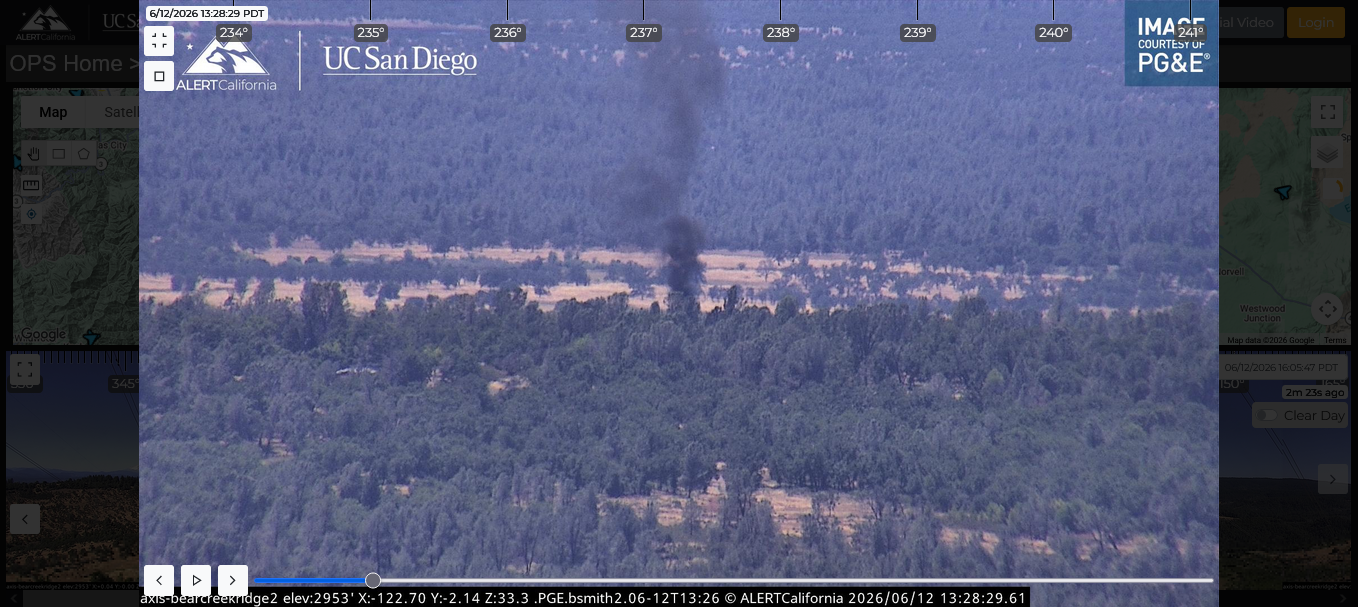
|
2026 06
12 (Friday) Vehicle Fire Dersch / 44.
No spread to Vegetation. Thank you S6 (Village) (59)
K6PDS (mobile / Redding). Bear Creek Camera 37.28 Deg.
T SER Advisory issued.
|
|
2026 06 12 (Friday) 0952 Hours Random
TEST 9
57 no notice /
no activation / no tone out. Request: Any 1 station respond. Responses:
G7 F2 KK6SWE - ALL Q5
|
|
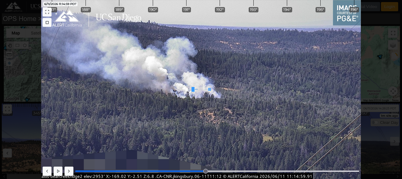
2026 06
11 - INWOOD FIRE -ARSON - Thank you
S6 for providing information.
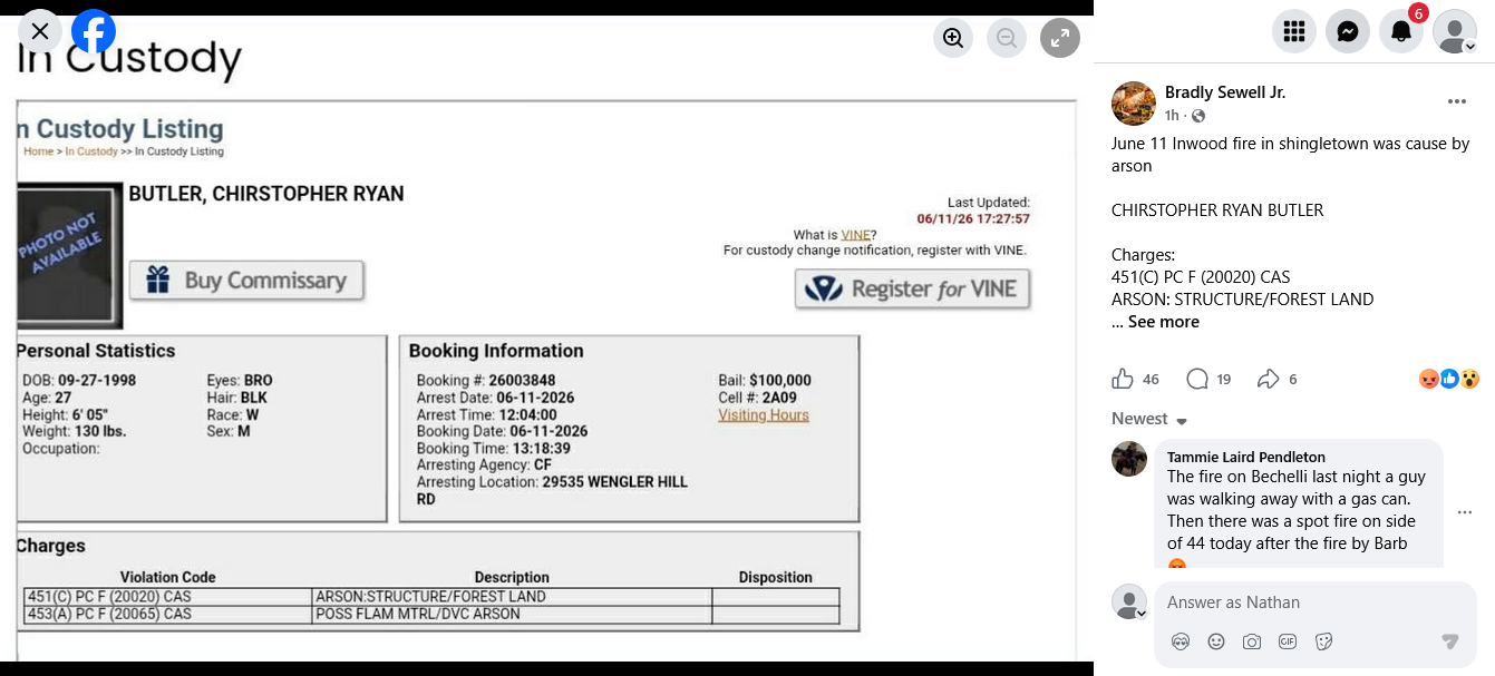
|
|
2026 06
11 -
INWOOD FIRE
Thank you to S6 for the excellent work done on the radio today
concerning the Inwood Incident (3.5 acres) and the Dersch /44
50 by 50 spot fire.
S6 and K6pds worked together on the radio reporting the
incidents (using multiple sources, internet and Cal Fire radio
traffic...). S6 was in the Village and PDS was in a parking lot
in Palo Cedro. Thank you to Sites 7, Sites 8 and KK6SWE
for responding on frequency. Others have reported they heard the
reports.
Radio plan updates continuing due to malicious repeater attacks.
|
|
2026 06 10 (Wednesday) Work still
being done to revise Emergency Communications Plan due to Malicious
Emergency Repeater Interference Attack. If
anyone has information as to the person doing this, please contact
SER 530-474-3267. These modifications are taking substantial
time. Such will also include need to access the mountain repeater
ad coordinate with Cal Fire. We are in Fire Season now. During the
recent PG&E Power Shut Off, some stations lost all of the
following during the outage: electrical power, Frontier Land Line,
Cell Phone and Internet. Radio was the only means available for
emergency communications.
|
|
2026
06 10 SER
Resource MAP
LINKS NOT WORKING.
Reason per following link:
https://www.shastacounty.gov/information-technology/page/geographic-information-systems-development-and-support
“Geographic
Information Systems Development and Support - ATTENTION -
ALL WEB MAP APPLICATIONS
ARE CURRENTLY UNAVAILABLE DUE TO A SERVICE OUTAGE.
MORE INFORMATION WILL BE
PROVIDED BY 2 P.M. ON 06/10/2026.
PLEASE CONSIDER VISITING
THE CITY OF ANDERSON, CITY OF REDDING, AND CITY OF SHASTA LAKE GIS
APPLICATIONS IF YOU NEED TO CONSUME INFORMATION WITHIN THOSE
JURISDICTIONS.”
|
|
2026 06 07 (SUNDAY) 1930 hours Cal
Fire Tone Out SMOKE CHECK.
SER Silent Monitoring ... E 2463 R ... in area of Ally
Gold Way / 44 ... Smoke Visible Bear Creek Camera 214.76 Deg
True (Significant) ... Cal Fire at scene - burn pile behind Black
Butte Market ... Cal Fire will be discussing with Homeowner ....
Silent Monitoring Deactivated 1941 hours.
|
|
We
have a good team and the individual doing the keying is destroying the
plan and risking lives. We are in Fire Season. This group
of keyings caused stations to wonder what was happening ....
Also, this keying started after a specific individual (who
previously actively sought to destroy the SER Program) observed
me at Reeds Market on 6-6-2026.
|
|
2026 06 07 (Sunday) 1211 Hours REPEATERS
DISABLED - INTERFERENCE WITH EMERGENCY COMMUNICATIONS PLAN
Keying without ID last night and multiple times
this morning (both repeaters)
Has someone given out the Codes?
Has someone provided a radio to someone not in
our group?
Is a team member keying without ID? This last
point is not very probable.
As of 1211
hours BOTH REPEATERS ARE DISABLED.
|
|
2026 06 06 (Saturday) 1313 Hours Random
TEST 9
55 57 no notice /
no activation / no tone out. Request: Any 1 station respond. Responses:
MWM (Q5 BOTH WAYS); F8
MW1
|
|
2026 06 05 (Friday) 1700 Hours Random
TEST
55 57 no notice /
no activation / no tone out. Request: Any 1 station respond. Responses:
MWM (Q5 BOTH WAYS); SITES
7 SITES 8 (Q5 WITH STATIC).
|
|
2026 06 05 (Friday) 1016 Hours Random
TEST
55 57 no notice /
no activation / no tone out. Request: Any 1 station respond. Responses:
on 57 PR87 on 55 PR87.
|
6 06 04 (Thursday) URGENT
Dear Radio Operators:
Today, we had someone keying and
the causing of substantive interference on the
emergency communication repeaters and keying
without ID.
We are in Fire Season. If
you know who the person is, please have them stop
it and call me immediately with their name(s).
The rule is that if you key our
frequencies, you must identify at all times.
The choices are: change
the repeater codes and all the radios; or shut the
whole thing down.
Two other groups had a less
structured communications plan, but they stopped
doing nets because of lack of participation.
On the other hand, the SER plan has some dedicated
operators and has a functioning specific plan
which historically has proven to be helpful during
wildfires, auto accidents (extraction from
vehicle), evacuation, relay of 911 calls,
communications during power failures and complete
communication blackouts, etc... .
It has taken a lot of work, time and money to
rebuild the SER system from the last time some
specific Shingletown individuals (including the
prior President of the local ham club) who
actively took action to destroy the only Radio
Emergency Communications system in Shingletown. Of
course those individuals had no plan at that time,
and don't have a plan now to provide potential
life saving information during a wild fire, etc...
. This impacts all of us.
Thank you for your attention to
this matter.
Nathan
|
|
2026 06 04 (Thursday) 1651 Hours Random
TEST
55 57 no notice /
no activation / no tone out. Request: Any 1 station respond. Responses:
Lava 7 LH
|
|
2026
06 04 (Thursday)
0944 hours
approx Random
TEST 9 55 57 - no
notice / no activation / no tone out.
Request: Any 1 station respond. Responses:
I1 MWM (55 Q5 BOTH WAYS) MW1 SWE (57
PDS REPORTED SWE READABLE / SWE REPORTED PDS BARELY
READABLE).
|
|
2026
06 03 (Wednesday)
0938 hours
approx Random
TEST 9 55 57 - no
notice / no activation / no tone out.
Request: Any 1 station respond. Responses:
LH
AI6D SITES
7 SITES 8
|
|
2026
06 02 (Tuesday)
0957 hours
approx Random
TEST 9 55 57 - no
notice / no activation / no tone out.
Request: Any 1 station respond. Responses:
S6 MW1 SWE
|
|
2026
06 02 (Tuesday)
0905 hours - Cal
Fire tone out - commercial vehicle fire truck brakes on
fire Dersch / 44 ... responding ... SER
silent monitoring activated (nothing visible on cameras ...) ..
Cal Fire at scene investigating ... nothing showing .. Cal Fire
cancel response ... 0917 SER silent monitoring
deactivated 0917.
|
|
2026
06 01 (Monday)
1147 hours
approx Random
TEST 9 55 57 - no
notice / no activation / no tone out.
Request: Any 1 station respond. Responses:
S6 MWM MW1
|
|
2026
05 31 (Sunday)
Missing Person -
TX on 9 55 57. Thank you S6 for the additional
information and link to below image.
Update:
5/31/2026 1800 hours - Sheriff is doing search. Staging from
Reed's Market, Shingletown.
https://www.facebook.com/groups/1802834543157216/media/
Photo was placed at Reed's and Shingletown Store. Thank you to
both stores.

|
|
2026
05 30 (Saturday)
1050 hours
approx Random
TEST 9 55 57 - no
notice / no activation / no tone out.
Request: Any 1 station respond. Responses:
I1 MWM (Portable) Sites 7 Sites
8 G7 LH
MW1
|
|
2026
05 28 (Thursday)
1900 hours
ACTIVATED - KNOW YOUR ZONE DRILL NET.
SUMMARY: 5 Areas
Reporting; 15 stations; 9 minutes (BELOW ARE
REPORTS) - ON 9 55 57:
VL: F1 -SHI 5420 F7-SHI 5420 F8-
SHI 5420 F2 -SHI 5420
B7-SHI 5430 B1-SHI
5430 S6-SHI 5420 S7-SHI
5420 I1- SHI 5420 G7-SHI 5440
LH: LH1- SHI 5390
MW: MW1- SHI 5335 MW2-SHI
5335
WH: SWE- SHI 5220
RA: WMW- SHI 5190B
NO REPORTS: PR SITES LAVA.
AFTER ACTION: ONE AREA
DIDN'T HEAR TONE OUT - THEIR RADIO WAS "DEAD" - IT WAS
NOT IN THE CHARGER PROPERLY AND WASN'T CHARGED. RECOMMEND
THAT YOU CHECK YOUR RADIO EVERYDAY TO MAKE SURE IN CHARGER (PLEASE
DO NOT PRESS PTT).
IF YOU ACCIDENTALLY PRESS THE PTT, PLEASE IDENTIFY AND
SAY --- "F1 ON 9,
DISREGARD, OUT").
YOU ARE AWARE THAT ONE TIME A DAY (RANDOM) A "TEST"
MAY BE DONE. Example " F1 ON 9,
TEST, 1 STN RESPOND, OVER". (REQUEST MAY BE FOR 2 OR 3
STATIONS TO RESPOND). THIS ALLOWS YOU KNOW YOU CAN
HEAR YOUR RADIO, LETS YOU RESPOND IF YOU DESIRE / ARE ABLE
(YOU CAN RESPOND [E.G., "G7
COPIES on 9 Q5"]; AND WE ARE TESTING TO ENSURE
THE REPEATERS ARE WORKING PROPERLY, ETC... THIS ONLY
TAKES ABOUT 30 SECONDS TOTAL FOR ALL CHANNELS 9
55 57.
IF YOU NEED TO DO A RADIO CHECK: SAY -
(E.G.,) "F1 ON
9, RADIO CHECK, OVER".
THEN ANOTHER STATION RESPONDS SAY-
(E.G.,) "F1,
G7 COPIES ON 9 Q5 (or say "PERFECTLY READABLE"
instead of "Q5")"
|
|
2026
05 28 (Thursday)
0920 hours
approx Random
TEST 9 55 57 - no
notice / no activation / no tone out.
Request: Any 1 station respond. Responses:
F2 B1 MWM MW1
|
|
2026
05 28 (Thursday)
1900 hours
SCHEDULED KNOW YOUR ZONE DRILL.
Tone out 1900 hours. Stations to respond with their ID and
Zone. e.g., CONTROL
.... ..." F7 GO..... "
STATION: "F7
ZONE SHI 5420 END REPORT"
CONTROL ". .... COPY F7, NEXT ..."
HERE IS THE LINK TO FIND YOUR ZONE: Go
to protect.genasys.com,
enter your address in the search bar, and
make note of what zone you are in. Recommend that you place this
ZONE NUMBER next to your Radio and in prominent locations in your
home.
|
|
2026
05 27 (Wednesday)
0953 hours
approx Random
TEST 9 55 57 - no
notice / no activation / no tone out.
Request: Any 1 station respond.
Responses: E1 MW1 G7
|
|
2026
05 26 (Tuesday)
1017 hours
approx Random
TEST 9 55 57 - no
notice / no activation / no tone out.
Request: Any 1 station respond.
Responses: S6 MWM MW2 (ALSO TX
ABOUT STARLINK MINI PROPOSAL)
|
|
2026
05 25 Proposal that an operator and/or multiple
operators incorporate into their evacuation Go Box a Star Link
Mini. During a Mobile Evacuation Net (e.g., wild fire evacuation)
such station(s), when at a safe location, would use this
tool to relay information into and out of the Mobile Net. Thank
you MWM for idea. This is to be part of the Shingletown Emergency
Radio Communication Plan. Volunteers please call to discuss
so a plan can be developed.
|
|
2026
05 25 (Monday
- Memorial Day)
1040 hours
approx Random
TEST 9 55 57 - no
notice / no activation / no tone out.
Request: Any 1 station respond.
Responses: I1 PCR
SWE MW1
|
|
2026
05 24 (Sunday)
1518 hours
approx Random
TEST 9 55 57 - no
notice / no activation / no tone out.
Request: Any 2 stations respond.
Responses: I1
MW1 MWM F7
|
|
2026
05 23 (Saturday)
0900 hours
approx Random
TEST 9 55 57 - no
notice / no activation / no tone out.
Request: Any 3 stations respond.
Responses: B1 G7 SWE S6 MW2
|
|
|
|
2026
05 22 (Friday)
K6PDS (F1)Took
reports from stations as to PG&E planned outage on 5/22/2026
at 2200 hours to 5/23/2026 at 0400 hours for Repair of
Equipment. Conducted on 9 55 57 -
one tone sent out.
Conclusion:
Areas from at least Midway and extending Eastward to Viola are
expected to have the above outage.
Responses T10 S1 I1 F1 F7
MW1 MW2 MWM PR87. Also confirmed Battle Creek by
phone and verbal as to Viola while at Reeds Market.
Concern - lack of notice by PG&E as to the extent of the
outage. The PG& E website doesn't appear to have any
information (as of this writing) about the outage. Thus, without
communication between areas, individually we would not appreciate
that this is a wide area outage and not restricted to just one
area / neighborhood. Emergency communications could impacted.
|
|
2026
05 21 (Thursday)
1845
hours Random
TEST 9 55 57 - no
notice / no activation / no tone out.
Request: Any 2 stations respond.
Responses: B1 S6 MW1 MWM
B1 F8 I1
|
|
2026
05 21(Thursday)
1550 hours - Cal Fire - Smoke Check - SER
Silent monitoring - in area of 8296 Pigeon Ln X viola
Meadows. SER estimated 99 true from Bear Creek Camera
- nothing showing ... Cal Fire responding ... E 2463 at
scene ... nothing showing on Camera .. SER DEACTIVATED SILENT
MONITORING 1623 HOURS.
|
|
2026
05 20 (Wednesday)
0955 ALERT
FM TEST WAS CONDUCTED BY SHASTA COUNTY:
SER Request made on 9 55 57 for stations with Alert FM
to advise if their Alert FM unit received the County Test:.
Following Station reported that their Alert FM device received the
County Test (THUS THEIR UNIT WAS WORKING): B1
F1 MWM S6 G7. No other stations
reported. NOTE: many people do NOT have the Alert FM DEVICE.
If you receive an FM Alert please transmit on radio the message so
more people receive the information.\
Great job B1 on 9.
NOTE: As of this writing, I had briefly searched the
internet to find out information about todays test. I was Unable
to find any information (I found multiple references to testing in
2024). The problem here is that if people don't know there was
going to be a test, they would not know that their unit failed the
test if it didn't activate. The only information on KRCRTV.COM was
information about a test 2 years ago.
|
|
2026
05 19 (Tuesday)
1855
hours Random
TEST 55 57 9 - no
notice / no activation / no tone out.
Request: Any 2 stations respond.
Responses: LH
F2 MWM MW2
G7
|
|
2026
05 19 (Tuesday)
0952
hours Random
TEST 55 57 9 - no
notice / no activation / no tone out.
Request: Any 1 station respond. Responses:
S6 G7 G7 S6
|
|
2026
05 18 (Monday)
1034
hours Random
TEST 55 57 9 - no
notice / no activation / no tone out.
Request: Any 1 station respond. Responses:
S6 MW1
PR87 F7
|
|
2026
05 17 (Sunday)
1245
hours Random
TEST 55 57 - no
notice / no activation / no tone out. K6PDS
mobile with mobile mag mount antenna in Redding (area
of Churn Creek and Dana). Request: Any 1 station respond.
Response: MWM (readable on 55 and 57 both on
high power (50 watts) and low power (5 watts).
|
|
2026
05 16 (Saturday)
1059
hours Random
TEST 55 57 9 - no
notice / no activation / no tone out.
Request: Any 1 station respond. Responses: Sites
7 Sites 8 F7 MW1
|
|
2026
05 15 (Friday)
(1800 hours)
Information /
Advisory: Red Flag warning issued from today through May 18, 2026.
On 55, 57 9
PDS Requested any 1 station acknowledge TX.
Responses:
G7 F7
MW1 LA 7
|
2026
05 15 (Friday)
Random
TEST no notice 55 / 57 - no activation / no tone out.
Wild Fire Communications and Evacuation Communications. The
below is done in about 40 seconds or less. This is not a
"monitoring check" or "activation". It
merely tests the repeaters, let's us know that someone is
actually monitoring, and lets you very briefly practice critical
communication skills for potential evacuations when your radio
is going to be moving with you and not static at your home..
I slightly revised the procedure for purposes of getting
operators used to changing frequencies during communications (if
needed). This is to prepare us for potential wild fire
evacuations. Control initiates as follows::
"Testing 55 and 57. Control on 55;
any 1 (or other #) stations respond on either 55 or 57
over"
YOU THEN RESPOND (with your ID) ON EITHER 55
OR 57 based on where you get the best communications (or
to see how well you are heard and can be heard on a specific
repeater).
I then duplicate the above procedure on the other repeater.
Thus,
"Testing 55 and 57. Control on 57;
any 1 (or other #) stations respond on either 55 or 57
over"
Why the above? Because depending on where you are
located, you may be able to get into 1 repeater better than the
other (they are about 13 miles apart and at different
elevations). You could be on a road, highway, or weather
conditions are impacting radio communications, etc... .
Also, if there is an emergency and you hear static on one of the
repeaters. When it sounds clear, transmit into the other
repeater and ask them to "repeat" on the other
repeater. (e.g., they are transmitting on 57, but all you
hear is static, then you would say on both repeaters
"F1 on ___" "repeat on 55, over").
Don't explain how you can't hear just say "repeat on
___". Thus, work both repeaters to get good
communications. If both repeaters are down, you try
simplex on 56 to see if direct communications can be done (i.e.,
radio to radio not going through any repeater).
Our test this morning had the following responses (good):
MWM G7 SITES 7 MW1 PDS (me).
Please call with any questions.
Nathan (K6PDS) 530-474-3267
|
|
2026
05 14 (Thursday
1443) Test No Notice No Tone
No Activation: . , Response:
. F7
, I1 MW1
|
|
2026
05 14 (Thursday
1306 hours) Cal Fire Tone out - Smoke
Check in Area of Doodle Bug and Wengler Hill Road. SER Silent
Monitorning - Bear Camera Smoke Column reacting to winds and
growing in size... Bear Creek Camera 169.68 degrees T.
Winds out of NW 7 to 8 MPH. Approx Distance to village - 2
miles NW of Village. No Cal Fire Radio Traffic except for
Phone call to Chief ... 1335 hours smoke reducing ... Cal
fire advises will update with address and out with homeowner ...
1350 hours smoke almost gone ... 2463 hours radio traffic -
Homeowner issued something from Law Enforcement .. (appears to
have been illegal burn). Silent Monitoring deactivated
1410.
|
|
2026
05 13 (Wednesday
1218) TX . ,
that updated Evacuation procedures - Overview was e-mailed
and that such document is also available at Shasta Defense.
Response: Sites 7 Sites
8
I1 MW1.
|
|
2026
05 12 (Tuesday
0922) FRONTIER INTERNET OUTAGE AND FRONTIER LINE FAILURE (NO DIAL
TONE) - RADIO REPORTS CONFIRMED OUTAGE LIMITED TO VILLAGE AREA:
Restoration of service 0954 hours. Stns reporting and
assisting: F1 I1 S1 S2
G7 MW1.
|
|
2026
05 12 (Tuesday
0910
hours)
Random
TEST no notice 57 - no activation / no tone out
Requested
any TWO stations to respond. Response ON 57:
G7 I1 LH PR87 MW1.
|
|
2026
05 11 (Monday
1012
hours)
Random
TEST no notice 57 - no activation / no tone out
Requested
any TWO stations to respond. Response ON 57:
I1 F7
|
|
2026
05 09 (Saturday
1038
hours)
Random
TEST no notice 57 - no activation / no tone out
Requested
any TWO stations to respond. Response ON 57:
F2 I1 F7
|
|
2026
05 07 (Thursday
1900 hours)
WILDFIRE
AND EVACUATION PREPARATION,
Mobile
RADIO Evacuation Drill conducted.
Thank you to all stations participating in the Mobile Radio
Evacuation Drill: G7 L9 SWE I1 T10 MWM PDS.
Thank you to AJ6KJ and T10 for their telephone recommendations
for improving the procedure. These are being incorporated.
The community can benefit from your radio reports during a
Sheriff Evacuation Order. We will be conducting another drill and
invite more team members to participate.
|
|
2026
05 07 (Thursday
1110 hours)
Random
TEST no notice 55 / 57 - no activation / no tone out.
[Q5 MEANS PERFECTLY READABLE].
WILDFIRE
AND EVACUATION PREPARATION, DRILLS.
K6PDS was ON 55 THEN 57 and REQUESTED ANY THREE STATIONS TO RESPOND ON EITHER 55
or 57 and advise which repeater they were responding on:
. Responses:
F7 ON 57 (F7 ADVISED PDS NOT READABLE WHEN PDS ON 55). WHEN
BOTH STATIONS WERE ON 57, COMMS WERE Q5 FOR EACH STATION.
IN
THIS CASE, EACH STATION WAS ON THE SAME
REPEATER AND WERE PERFECTLY READABLE BY
EACH OTHER.
F2 ON 57 (F2 ADVISED ONLY HEARD STATIC ON 55). WHEN
BOTH STATIONS WERE ON 57, COMMS WERE Q5 FOR EACH STATION.
SITES 7 & 8 (SITES 7 & 8 BAREY READABLE BY PDS WHEN
SITES WAS ON 57. NOTE DIFFERENCE IN THIS CASE: WHEN PDS
WAS ON 57 AND SITES 7 & 8 WENT TO 55 COMMS WERE Q5 BOTH WAYS.
NOTE: THUS,
IN THIS CASE, EACH STATION WAS ON A DIFFERENT
REPEATER AND WERE PERFECTLY READABLE BY
EACH OTHER. This result can be achieved because of
how the repeaters and your radios are programmed. AFTER
ACTION: ABOVE ILLUSTRATES HOW PROPAGATION (WHICH CAN
CHANGE MINUTE BY MINUTE) IMPACTS WHICH REPEATER YOU CAN HEAR
AND BE HEARD ON BETTER. THUS, SUMMARY REPORTS AND
NEEDS, ROAD CONDITIONS, FIRE NETS, EMERGENCIES, SIT REPS, QWA,
ETC...) SHOULD BE REPEATED ON BOTH REPEATERS SO THERE IS MAXIMUM
COVERAGE OF AREAS. STATIONS NEED TO BE ABLE TO
CHANGE CHANNELS EASILY. THE REPEATERS (55 57) ARE ABOUT 13
MILES APART AND AT DIFFERENT ELEVATIONS. Note: if you hear on "59" that is a special
for certain radios. Stations can treat it as same as 57.
|
|
2026
05 06 (Wednesday
1852 hours)
Random
TEST no notice 55 / 57 - no activation / no tone out.
WILDFIRE
AND EVACUATION PREPARATION / DRILLS.
K6PDS was ON 55 and REQUESTED ANY FOUR STATIONS TO RESPOND ON EITHER 55
or 57 and advise which repeater they were responding on:
. Response ON 57:
"G7 on 57"; SWE ON 57;
SITES 7 AND SITES 8 ON 57.
Response ON 55: "MWM ON
55" IF YOU DIDN'T HEAR PDS OR MWM
ON 55, YOU MAY NEED TO IMPROVE YOUR ANTENNA SET UP. Purpose of above: For Emergency
communications have stations recognize that they use whichever
repeater they can achieve good communications on based on their
location. Note: if you hear on "59" that is a special
for certain radios. Stations can treat it as same as 57.
|
|
2026
05 06 (Wednesday
0959
hours)
Random
TEST no notice 55 / 57 - no activation / no tone out
K6PDS was ON 55 and REQUESTED STATIONS TO RESPOND ON EITHER 55
or 57 and advise which repeater they were responding on:
. Response ON 57:
"G7 on 57"
Response ON 55: "W6MWM ON
55"
The above only stations responding: Need Improvement on
Monitoring. Purpose of above: For Emergency
communications have stations recognize that they use whichever
repeater they can achieve good communications on based on their
location. Note: if you hear on "59" that is a special
for certain radios. Stations can treat it as same as 57.
|
|
2026
05 05 (Tuesday
0944
hours)
Random
TEST no notice 57 - no activation / no tone out
Requested
any TWO stations to respond. Response ON 57:
E1 (ON 9); MW2 i1
|
|
2026
05 04 (Monday
1022
hours)
Random
TEST no notice 57 - no activation / no tone out
Requested
any TWO stations to respond. Response ON 57:
F2 MW2
|
2026
05 02 TRAINING SESSION FOR EVACUATION MOBILE NET SET FOR MAY 7,
2026 AT 1900 HOURS ON 57. WILDFIRE
PREPARATION - RADIO TEAM. Non Team residents can listen if
they have programmed radios (call 530-474-3267). Need to be in
radio range / propagation varies. This is all volunteer.
We will do an Evacuation Drill Radio Training Exercise on May
7, 2026 at 1900 hours (7:00 P.M.) on 57. K6PDS will start and
then stations are requested to participate as set forth in the
drills. Everyone should participate in at least one drill
exercise. These are simple, but get the concept across. All
participating stations should be able to participate because we
are using 57.
Even if you don't plan on ever evacuating, you may have
information that others need. For example, you see a road which
is blocked by wildfire and people can't use it, etc....
or, someone else has information which you need, you need
a 911 relay and your phones are not working, etc...
|
|
2026
05 02 (Saturday
1015
hours)
Random
TEST no notice 57 - no activation / no tone out
Requested
any THREE stations to respond. Response ON 57:
SITES 7 SITES 8 Q5 SOME STATIC; LH Q5
|
|
2026
05 01 (FRIDAY)
FRONTIER INTERNET OUTAGE (LIMITED) B1 and G7
reported Frontier internet outage in their area. No other reports
of outages in Area. (both of these outage areas are closer
to Highway 44 and are East / West of each other).
K6PDS responded on radio (while 24 miles awary from Village)
while mobile in Redding and contacted Frontier Local Contact
via Cell phone (Chris) - left messages. B1 (also his Frontier Land
Line not working and his cell phone reception is not good at his
location) contacted frontier and obtained a ticket #2179289. A
Frontier Truck with operator was in area (Village). Both B1 and
PDS (upon driving into Village when returning from Redding) asked
him for assistance - he advised he didn't do that work (but told
PDS he would adivse Chris). NOTE: relying on Frontier Internet
during Fire Season (e.g., to view Fire time Cameras) is a poor
choice. Same concern with Frontier land line. Frontier ignores
problems and failures. Frontier set ticket response for B1 as next
week. Several people are going to Star Link.
Using RADIO communications between stations is important as
resources can be shared depending on who has what; and different
services may be working vs. not working.
|
|
2026
05 01 (FRIDAY
1100
hours)
Random
TEST no notice 57 - no activation / no tone out
Requested
any TWO stations to respond. Response ON 57: MWM
(PDS heard MWM Q5 with static / MWM advised difficult to
read PDS. MWM was only station to respond. After
Action: Monitoring /
Response needs to improve. Recommend Team carry radios with
them when away from home.
If you hear the radio, please respond We only have 2 other
Shingletown hams helping. We need more hams. The
NON Hams are the backbone of the system so please step up.
|
|
2026
05 01Please read the updated Evacuation Net
Script. If have comments, please advise.
The Drill Examples are being updated. We will set a date for
Radio Drills.
|
|
2026
04 30 (Thursday
0850
hours)
Random
TEST no notice 57 - no activation / no tone out
Requested
any TWO stations to respond. Response ON 57: G7
Q5 F2 Q5
|
|
2026
04 29 (Wednesday (1045
hours)
Random
TEST no notice 57 - no activation / no tone out
Requested
any TWO stations to respond. Response ON 57: i1
Q5 G7 Q5
|
|
2026
04 28 (Tuesday (0910
hours)
Random
TEST no notice 57 - no activation / no tone out
Requested
any TWO stations to respond. Response ON 57: F2
Q5 KK6SWE Q5 A LITTLE SCRATCHY
|
|
2026
04 27 (Monday) (0920
hours)
Random
TEST no notice 57 - no activation / no tone out
Requested
any TWO stations to respond. Response ON 57: S6
Q5
SITES 7 SITES 8 Q5 A LITTLE SCRATCHY
|
|
2026
04 26 (Sunday) (1433
hours)
Random
TEST no notice 57 - no activation / no tone out
Requested
any TWO stations to respond. Response ON 57: G7
Q5 MW2 LIGHT BUT READABLE
SITES 7 SITES 8 Q5 A LITTLE SCRATCHY
|
|
2026
04 25 (Saturday) (1115
hours)
Random
TEST no notice 57 - no activation / no tone out
Requested
any TWO stations to respond. Response ON 57: i1
|
|
2026
04 24 (Friday) (1108
hours)
Random
TEST no notice 57 - no activation / no tone out
Requested
any TWO stations to respond. Response ON 57: S6
MWM MW2
|
|
2026
04 23 (Thursday) (1023
hours)
Random
TEST no notice 57 - no activation / no tone out
Requested
any TWO stations to respond. Response ON 57: LH
Q5 F2
Q5 PR87 Q5
|
|
2026
04 22 (Wednesday) (0941
hours)
Random
TEST no notice 57 - no activation / no tone out
Requested
any TWO stations to respond. Response ON 57: PR87
Q5 F2 Q5
|
|
2026
04 21 (Tuesday) (1208
hours) WATER ISSUE VILLAGE: No
water F1 F7 F14; Weak water: F2; Good Water
pressure S6 B1; E1 good water pressure but not on
village system. Report from S1 S2 - VL water
company flushing system, thus various locations in Village will
have short term issues with water pressure. Duplicated
summary report on 57.
|
|
2026
04 21 (Tuesday) (1156
hours)
Random
TEST no notice 57 - no activation / no tone out
Requested
any TWO stations to respond. Response ON 57:
F2 Q5 LH Q5 B1
Q5 SITES 7 &8 (readable but scratchy)
|
|
2026
04 20 (Monday) (1604
hours)
Random
TEST no notice 57 - no activation / no tone out
Requested
any TWO stations to respond. Response ON 57:
F2 Q5 MW2 Q5
|
|
2026
04 19 (Sunday) (1742
hours)
Random
TEST no notice 57 - no activation / no tone out
Requested
any TWO stations to respond. Response ON 57:
F2 Q5 PR87 Q5
|
|
2026
04 18 (Saturday) (1852
hours)
Random
TEST no notice 57 - no activation / no tone out
Requested any TWO stations to respond. Response ON 57:
MWM (readable wth static) i1 Q5
|
|
2026
04 17 (Friday) (1830
hours)
Random
TEST no notice 57 - no activation / no tone out
Requested
any TWO stations to respond. Response ON 57:
G7 Q5 LH Q5
|
|
2026
04 15 (Wednesday) (1947
hours)
Random
TEST no notice 57 - no activation / no tone out
Requested
any one station to respond. Response ON 57:
F8 Q5
|
|
2026
04 11 Monitoring Check - Random No Notice (1158 HOURS): on
9
55 57:
RESPONSE: F1
(K6PDS) F7
I1 S6 S7
G7 MW1
MW2 PR87.
|
|
2026
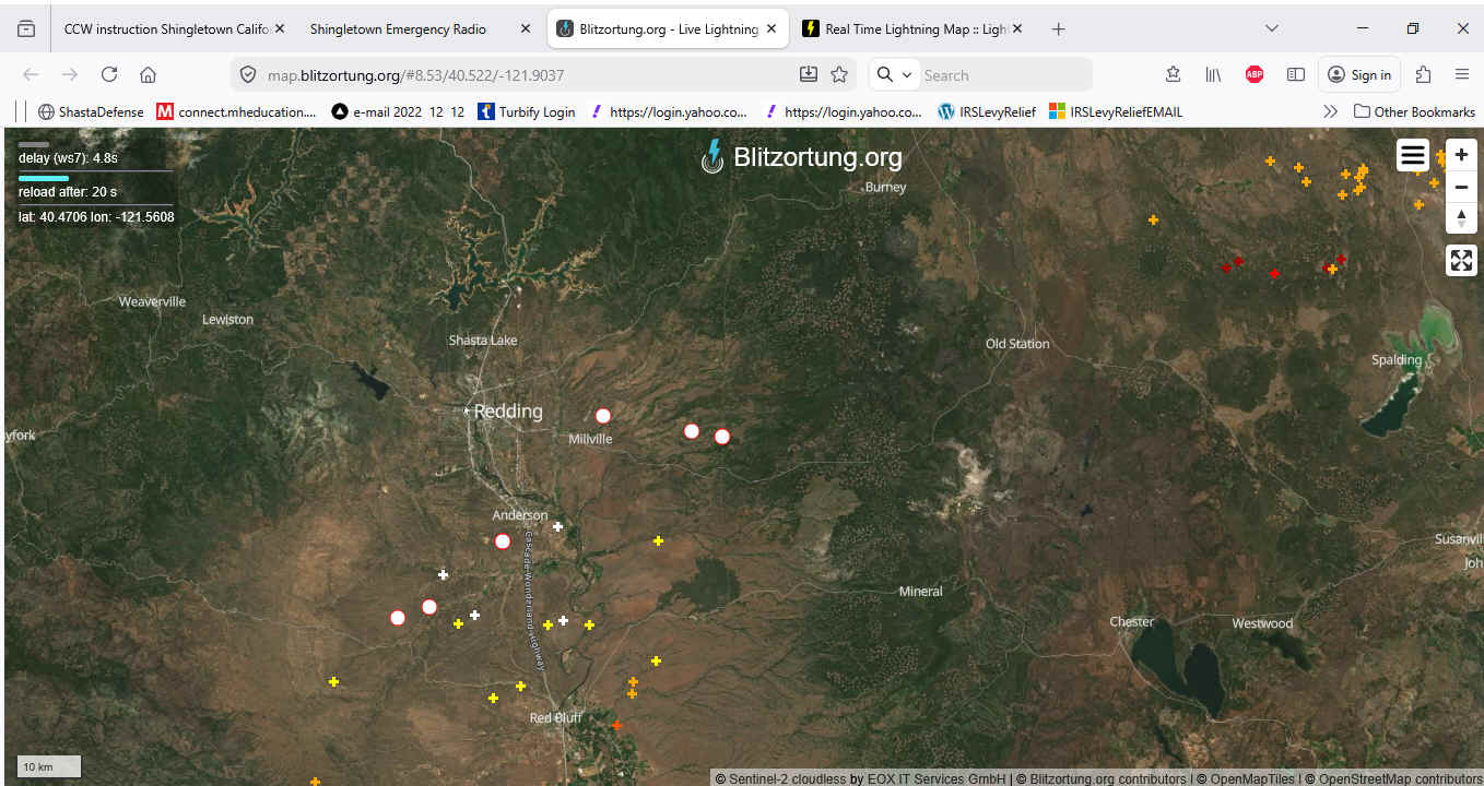
04 08 (evening) Lightening - Stns conduct QWA when
out. Stikes can take a while before ignition. Following Lightening
Strtikes, a fire may develop
over the course of a short time, up to approx. 2 weeks. Thus, if station operators are driving,
they should have a higher level of alert during such times. Have your radio, cell phone and a
compass to give bearings, etc…
Thank
you S6 for the image directly below www.weatherbug.com
|
|
2026
04 09 is dated set for Village Planned Power outage per PG& E letter
to be between 0930 and 1000 hours and again between 1500 and 1530
hours.
|
|
2026
04 08 (1100 hours) Frontier LL failure and Frontier Internet
Failure VILLAGE. Stns reporting
outages: S6 F1 F7 T10 I1
S1 S2 G7 (a neighbor). MW1 reported both
operational.
Also, S6 advised per PG & E Power Map a portion of Sleepy
Hollow has Power Outage.
Areas Not Responding to report request: LH WH
PR SITES RA.
I1 contacted Frontier (via Cell) - Frontier advised of no
outage. Will send someone out. F1 called and left voice
message for local Frontier Manager advising of outage. Text
from Frontier - outage being worked on. Expected restoration of
service 4 -8-2026 2315 hours
UPDATE: VILLAGE FRONTIER LAND LINE AND INTERNET
RESTORED 1322 HOURS. Responding 9 55 57 :
K6PDS F1 S6 I1 MW3
|
|
2026
04 08
0824 hours CAL FIRE TONE OUT STRUCTURE FIRE MANTON
AREA Rock Creek IC
Tac 11 IN AREA OF 31717 Rock Creek Road -121.871
40.439 Appr 2.3 miles SE of Wilson Hill Camera and 1/4 mile NE of
Manton. Shingletown Camera 162.72T Inskip
31.35T. Advisory on 55 (copy MWM S6). Confined
to out building and 1 vehicle .... Deactivated advisory on
55 at 0935 HOURS. (image Rock Incident)
|
|
2026
04 07 (Tuesday) (0945)
Random
TEST no notice 57 55 - no activation / no tone out
Requested
any one station to respond. Response ON 57:
S6 LH MW2 (READABLE - RUBBER DUCKY)
Response ON 55: MW2
(NOT READABLE ON 55); MWM - Q5.
|
|
2026
04 06 (Monday) (1009)
Report
on 55 from Ai6D (Redding) - Internet and Cell phone outages from
Red Bluff to Redding. K6PDS copied on 55.
THANK YOU BILL - AI6D. Shingletown - no reported outages.
|
|
2026
04 06 (Monday) (0943)
Random
TEST no notice 57 55 - no activation / no tone out. K6PDS Requested
any one station to respond. Response ON 57:
G7 (Q5)
Response ON 55:
G7 (COPIED G7 SCRATCH BUT READABLE).
|
|
2026
04 04 (Saturday) (1959)
Random
TEST no notice 57 (rptr)- no activation / no tone out. K6PDS Requested
any one station to respond. Response ON 57:
G7 B1
|
|
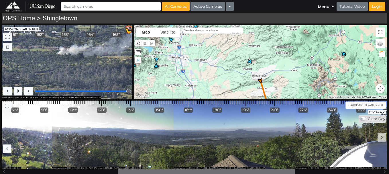
Remember the Park incident – 2024 07 31 Camera Mapping
1030 hours with approx distances from northern edge of fire to
Shingletown locations (estimated) HERE
And
April , 2026: Springs Fire on April 3, 2026 in Moreno
Valley, California. A fast-moving brush fire east of Moreno
Valley grew to about 3,500 acres on April 3, prompting evacuation
orders and road closures.
|
|
2026
04 04 (Saturday) (1120)
Random
TEST no notice 57 (rptr)- no activation / no tone out. K6PDS Requested
any one station to respond. Response ON 57:
RESPONSE FAILURE
1203 hours - 55 TEST - Response: MWM (Q5) (MWM
advised only heard static during 57 test. Thus, propagation is
a BIG factor in using 57 and 55. Sometimes MWM hears 57 Q5,
other times only hears static. CONCLUSION: NEED TO USE BOTH
TO MAKE SURE EAST AND WEST COVERED.
|
|
2026
04 03 (Friday) (0936
hours)
Random
TEST no notice 57 (rptr)- no activation / no tone out. K6PDS Requested
any one station to respond. Response ON 57: S6
Note:
The most recent Al-Qaeda of the Arabian Peninsula’s publication,
Inspire Guide #12, Spring 2026 is written in English. It contains
specific step by step instructions for building IEDs (e.g., pipe
bombs, etc…). It glorifies the Bondi Beach attack and is a
direct call to action by Muslims living in the United States and
Europe to attack religious gatherings here on the Homeland. It was
published weeks before Resurrection Sunday. Be aware of your
surroundings for the safety of you and your family. (Thank you CWT
for information).
|
|
2026
04 02 (Thursday) (1012
hours)
Random
TEST no notice 57 (rptr)- no activation / no tone out. K6PDS Requested
any one station to respond. (cold / had hail in
Village before dawn)
Response ON 57: S6
PR87
|
|
2026
04 01 (Wednesday) (1329
hours)
Random
TEST no notice 57 (rptr)- no activation / no tone out. K6PDS Requested
any one station to respond. (Rain
/ Wind)
Response ON 57: S6
|
|
2026
03 30 (Monday) (1101
hours)
Random
TEST no notice 57 55 (rptrs)- no activation / no tone out. K6PDS Requested
any one station to respond.
Response ON 57: S6
Response ON 55: S6
|
|
2026
03 29 (Sunday) (1508
hours)
Random
TEST no notice 57 55 (rptrs)- no activation / no tone out. K6PDS Requested
any one station to respond.
Response ON 57: G7
Response ON 55: W6MWM
|
|
2026
03 28 (Saturday) (1055
hours)
Random
TEST no notice 57 55 (rptrs)- no activation / no tone out. K6PDS Requested
any one station to respond.
Response ON 57: W6MWM
(Q5 a little static both ways)
Response ON 55: W6MWM (Q5 a little
static both ways)
|
|
2026
03 27 (Friday)
(1725
hours) Replacement backup batteries
installed and operational for 57. Copy TX: LH,
SWE.
Note: 2 - 6 volt: Interstate GC2 ECL Util Deep Cycle
Extreme.
|
|
2026
03 27 (Friday) (1024
hours)
Random
TEST no notice 57 55 (rptrs)- no activation / no tone out. K6PDS Requested
any one station to respond. Response ON 57:
PR87
Response ON 55: G7
|
|
2026 03 26
Power outage and small fire:
1345 hours (approx) Power
outage reported for:
Village, Pine
Ridge, Midway, Long Hollow; and mobile observation of outage
for: area near Shingletown Library,
Reeds, Shingletown Store, Dollar General.
Wilson Hill – No Power outage.
S6 reported during power outage (approx 1402 hours)
- electrical hazard Cal Fire tone out - smoking
transformer (sparking). There was a resulting small fire
at base of power pole ( in area of 30544 Thumper Drive). Cal Fire
Responded and at scene 1415 hours (per T10).
S6 reporting per Cal Fire Radio traffic they can handle with
engine at scene. PDS mobile, observed small approx
2’ X 2’ spot fire
– Cal fire extinguished.
S6 reported power outage also in rental near Library. S6
reported Cell and internet operational. PDS mobile, power out at:
Reeds; Shingletown Store and Dollar General. i1 reported
that per PG&E phone call estimated time for power restoration
to be 1615 hours.
PG& E arriving at scene 1427 hours
(per T10). S6 reported per Cal Fire radio traffic fire contained
and no powers lines down (S6). T10 reported 2 PG&E units at
scene - 1434 hours.
Power Restored for most stations
approx 1455 hours; and as of 1500 hours all areas reporting power
restored.
Above reports
and activity were transmitted on SER Emergency Radio Channels Ch
9, 57 and 55 (combination of backup batteries and generator
power).
Those reporting and contributing included:
S6 F2
F1(K6PDS) F7
I1 E1 LH
MW2 B1
PR87 T10
G7 MWM (Rest Area)
SWE (Wilson Hill).
Great
Job!
Additionally,
F1 F7 PR87 had cell phone failure during above
incident. Some persons only have cell phones, thus, unable to call
911. Also, during above incidents (power outage, fire, cell
outage), 57 had a power failure problem - K6PDS worked on this and
quickly brought 57 back on line (55 56 used during such
period).
|
|
2026
03 26 (Thursday) (1114
hours)
Random
TEST no notice 57 (rptr)- no activation / no tone out. K6PDS Requested
any one station to respond. Response ON 57:
S6.
|
|
2026
03 25 (Wednesday) (1338
hours)
Random
TEST no notice 57 (rptr)- no activation / no tone out. K6PDS Requested
any one station to respond. Response ON 57:
S6 B1 LH.
|
|
2026
03 24 (Tuesday) (1205
hours)
Random
TEST no notice 57 (rptr)- no activation / no tone out. K6PDS Requested
any one station to respond.
Response ON 57, S6 (Q 5
BOTH WAYS) and KK6SWE (scratchy but readable both ways - SWE
location Wilson Hill). Note: K6PDS was
transmitting from Redding (Michaels Parking Lot on Hilltop) using
Hand Held with Rubber Ducky 5 watt.
Illustrates the benefit of carrying your Hand Held Radio with you.
|
|
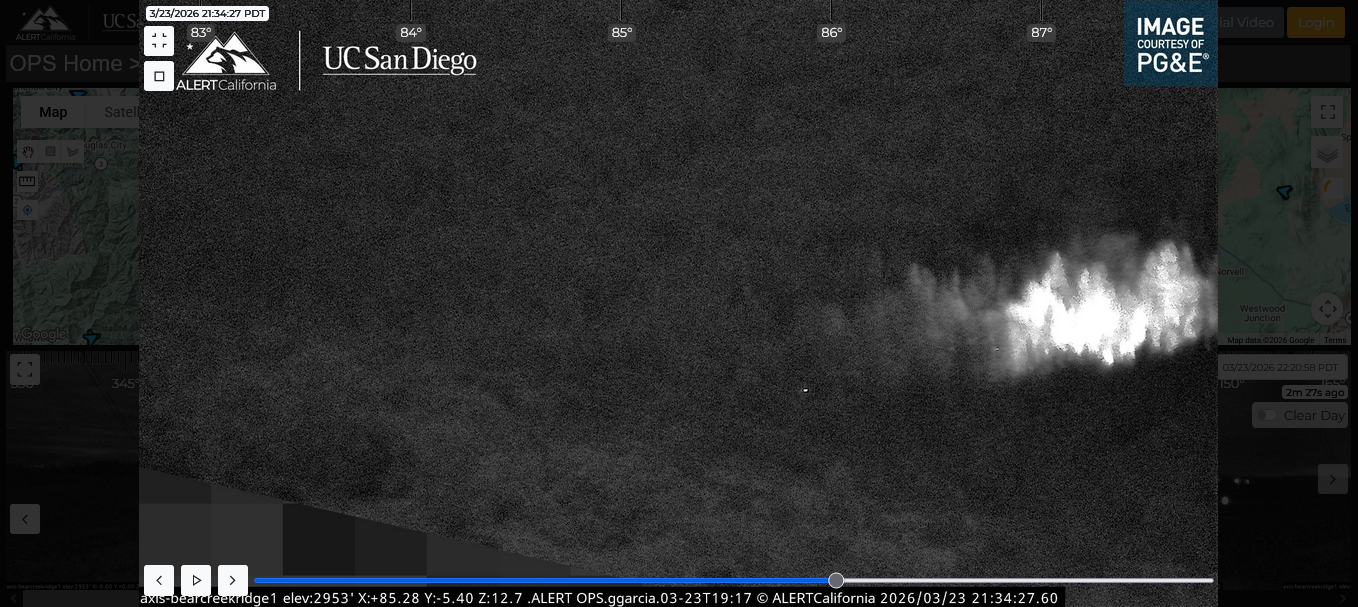
2026
03 23 (Monday)
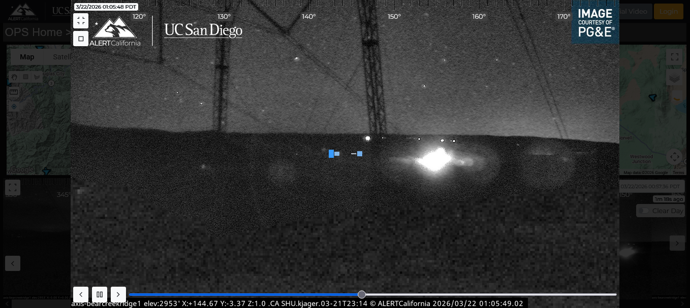
approx 2215 hours - K6PDS observed smoke / fire on Bear
Creek Camera 1 (bearing 87.24 deg True.
SILENT MONITORING ACTIVATED ... (only 1 camera bearing
available) therefore estimated location using terrain and
maps together with the camera bearing. Estimated location JNO
(just North of) Bonnie Crags, and about 1.5 miles west of
Chalk Mountain; and JEO (just East of) Ponderosa way.
Monitored situation until approx Midnight 20 hours after viewing
substantial reduction in fire intensity. Internet Winds over area
9 MPH out of the south. Fire was located about 4
miles northerly of the center of the Village and 2.75 miles
northerly of Long Hollow. SILENT MONITORING
DEACTIVATED MIDNIGHT 25 HOURS
3/24/2026. Per TCW Cal Fire understand
this may have been an escaped burn pile. If anyone has additional
information, please advise 530-474-3267.
Earlier screen shot of fire is below.
|
|
2026
03 23 (Monday) (1449
hours)
Random
TEST no notice 57 (rptr)- no activation / no tone out. K6PDS Requested
any one station to respond.
Response ON 57, G7. Time
10 sec. Note: CW ID not heard on tone squelched radios as
per Repeater Change.
|
|
3/24/2026 approx 1625 hours checking Shingletown
Camera. It appears to have been fixed, except it appears to
be off by 3 degrees.
|
|
3/23/2026 0945 hours:
Observed Shingletown Camera has WRONG degree bearings.
Examples Inskip is shown as 105 Deg. But is actually (i.e.,
should be) 202 Deg.
Mt Lassen is shown as 355 Deg but in reality it can't be
viewed from
Shingletown Camera.
Camera pointing towards smoke (earlier) indicating in direction
of highway 44, but in actuality location is in the
Manton area.
Action: Contact made with Emergency. Communication
Chief and he is going to look into it.
Nathan K6PDS
|
Repeater Changes
CHANNEL 57:
People heard the repeater ID around Midnight while we were
searching for the source of fire. If your radios are
set properly you should NOT have heard any voice; however, the
CW ID (in morse code) was heard. If you did hear voice, then
please call me - 530-474-3267.
I have now changed the repeater programming to avoid having the
CW ID heard by the Teams members. Thus, you should no longer
hear the CW ID on 57. The repeater still ID's in accordance with
FCC rules; however, it is NO longer encoded to open your radios.
Your radios will still "light" up, but you shouldn't
hear CW.
CHANNEL 55:
Changes will also be made to 55 (the repeater), but I have to go
to the mountain to make them. So on 55 you will still hear CW ID
(Morse code) because encode is still on.
Thank you.
|
|
2026
03 21 (Saturday Late) 2026 03 22 (Sunday
after midnight)
- Silent
Monitoring with Mobile observations.
INFORMATION: I was not going to post this; however, in light
of the Response failure on 55 (Sunday), decided to do
so. We need to have our radios on 24/7 and we all
should be taking a hand held radio with us when in the yard or
away from home. The repeaters help with hand held radio
communications.
Late Saturday 2026 03 21 (about 2300 hours, and before)
observed fire situation from Bear Creek Camera (AZ 155 - 156 Deg
T). No other camera was directed to this location therefore could
not use the cameras to triangulate on the fire. I called 911 and
spoke to a person who accessed the cameras and advised me that
there were (with words to affect) AG burns in Hat Creek. I
advised that is the wrong direction. I was then told it might be
burn piles in Manton. I checked the Manton camera and on this AZ
there was nothing showing. So this information was not
correct. I was later told that the Aldridge Ranch had burns.
None of this made sense, I felt like random statements were being
made to me without any analysis. I went mobile. From the
power lines on 44 viewing North, nothing visible. I went to
Dersch / 44 and drove back heading East and viewing the area near
the Bear Creek Camera - nothing visible. I next took Inwood
Rd. to Ponderosa and headed north (a short distance) on Ponderosa
Way. Again, nothing visible in the direction of Bear Creek Camera
and South Easterly thereof. However, Just North of Ponderosa Way
and Inwood and viewing to the South East at bearing 162 deg true I
observed smoke and fire. I drove back to Inwood and
Ponderosa Way and headed to Withrow and headed East. At
30399 and 30395 Withrow Road (same drive entry)
I observed many fires over about a 1/2 acre or more
area. I don't know who if anyone was working the fire;
however, I flashed a very high intensity light about 20 to 25
times towards the building and the fire area, and called out for
anyone to answer. There was no response and I didn't see any human
movement in the area of the fires or hear any equipment.. This was
concerning. I observed the situation for a while and it appeared
"stable" (meaning, not increasing into the trees,
etc...). I attempted a cell call to 911 from that location
to update on my observations; however the cell didn't work.
I returned home and plotted my observations to my mapping and
confirmed this location was on the AZ showing from the Bear Creek
Camera. Also, traffic flow on the video play back showed that the
subject fire was South Easterly of Ponderosa (in the direction of
Withrow Rd) and not towards the Aldridge Ranch area. .I
called 911 and advised of my updated observations. The person
advised they would relay to the Captain. My monitoring
terminated about 0200 hours. F7 assisted with radio
communications during this time on a tone set which was set up to
not bother others. Thank you F7. K6PDS.
|
2026
03 22 (Sunday) (1503
hours)
Random
TEST no notice
55 (rptr) and 57 (rptr)- no activation / no tone out. K6PDS Requested
any one station to respond.
Response ON 55: Failure of response on
55
Response ON 57: LH, .
|
|
2026
03 21 (Saturday) (0945
hours)
Random
TEST no notice
55 (rptr) and 57 (rptr)- no activation / no tone out. K6PDS Requested
any one station to respond. Response ON 55:
SITES 7 SITES 8; ON 57: LH
SITES 7 SITES 8. Time 15
- 20 sec. [opportunity to test system and your ability to Transmit
/ Receive to/from the different repeaters and their locations -
approx 13 miles apart at different elevations]
|
|
2026
03 20 (Friday) (1836
hours)
Random
TEST no notice
55 (rptr) and 57 (rptr)- no activation / no tone out. K6PDS Requested
any one station to respond. Response ON 55:
SITES 7 SITES 8; ON 57: PR 87
SITES 7 SITES 8. Time 15
- 20 sec.
|
|
2026
03 19 (Thursday) (1904
hours)
Random
TEST no notice
55 (rptr) and 57 (rptr)- no activation / no tone out. K6PDS Requested
any one station to respond. Response ON 55
G7; ON 57, G7 S6 PR87. Time 15
- 20 sec.
|
|
2026
03 18 (Wednesday) (1900
hours)
Random
TEST no notice
55 (rptr) and 57 (rptr)- no activation / no tone out. K6PDS Requested
any one station to respond. Response ON 55
G7; ON 57, F8 G7. Time 15 sec.
|
|
2026
03 17 2059 hours - Cal Fire tone out - smoke
check 7682 Woodland way - unattended burn pile. (location in
Sites Area). SER Silent Monitoring. 2102 hours E 22
Responding ... 2107 hours E 22 at scene ... legal in
attendance burn pile E 22 Available. SER silent monitoring
deactivated.
|
|
2026
03 16 1929 hours Village Frontier Land
Line (NO DIAL TONE) and DSL (internet) OUTAGE.
Radio comms showed outage limited to Village.
Responding: F1 I1 F7 S2 S6 E1
MW2 SWE (WILSON HILL) MWM (REST AREA) SITES 7
SITES 8.
OUTAGE CONTINUED UNTIL SERVICE
RESTORATION ON 2026 03 17 AT 1031 HOURS.
Impacts for those using above services include:
inability to call 911; village water company alert phone
system non operational; inability to view fire cameras over dsl
internet as well as other emergency resources; persons using
voip unable to make 911 calls. Persons who rely on such services
may be the one person who becomes aware of an emergency, and
without other means of communication, can't advise neighbors.
|
|
2026
03 16 (Monday) (1822
hours)
Random
TEST no notice
55 (rptr) and 57 (rptr)- no activation / no tone out. K6PDS Requested
any one station to respond. Response ON 55 Sites 7
Sites 8; ON 57, S6. Time 15 sec.
|
|
2026
03 16 1015 hours Frontier Land Line
Outage (no dial tone) continues. Per Frontier, system being worked
on by technicians. S6 advised she also initiated a
trouble ticket last night. Impacts include: those relying on
Frontier LL can't call 911; Village Water company not able to send
out phone alerts to Village residents.
As of 1135 hours Dial Tone restored to Village (reporting
S6 F1).
|
|
2026
03 15 1329 hours Cal Fire Tone out -
Residential Structure Fire 8470 Starlite Pines
Road (oven fire spreading to cabinets)... cal fire
responding (Star Incident TAC 11)... SER Advisory (K6PDS) on
55 57 ... Engine on scene, light smoke showing ...1346
hours Star IC reporting Fire contained cancel all
incoming except company 20.
During above Residential structure fire incident, Frontier
Land Line Failure (no dial tone) in Village
(stations reporting on 9 55 57: F1
F7 I1 S1 S2)- PDS contacted Frontier local
person (1343 hours) and advised of NO DIAL TONE (he advised he is
looking into it). Also I1 contacted Frontier and advised of
situation (no dial tone). MW 2 reported Midway Frontier land line
operational.
PINERIDGE 87 ADVISED MADE CONTACT WITH FAMILY MEMBER LIVING
COUPLE OF DOORS AWAY FROM ABOVE FIRE.
Stations responding to 55 57 advisory: K6PDS, Sites
7 Sites 8 F8 F2, SWE i1 MWW
Pineridge 87 i1
Advisory deactivated 1352 hours. Note: 1437 hours - Star IC -
Incident concluded. Cause cooking. Damage $5,000.
|
|
2026
03 14 K6PDS (mobile / mag mount / 50
watt) Requested TEST of 57 from Gravel Pitt area. PineRidge
87 responded. Q5. Note: This TESTING is part of preparations
for fire season radio communications (from different locations and
conditions) and the ability of the Radio Team RX / TX.
Public can listen if they have programmed radio.
|
|
2026
03 14 Russia
Shuts Off Internet in Moscow as It Tests Nationwide Censorship
System...[Russia
is stepping up its tests of systems designed to keep millions of
people from accessing information online in times of political
unrest, shutting off mobile internet access in the capital in
recent days. (illustrates need for
backup communications plans)
|
|
2026
03 13 (Friday) (1930
hours)
Random
TEST no notice
55 (rptr) and 57 (rptr)- no activation / no tone out. K6PDS Requested
any one station to respond. Response ON 55 AND 57,
SITES 7 AND SITES 8.
|
|
2026-03-12
(Thursday)
Random No
Notice Monitoring check 57: 1927
hours.
Responses - 12 Stations in 6
Neighborhood AREAS
VL
F1 (K6PDS) F7 G7 F8 F2 I1
LH -
MW
MW2
WH
SWE
SITES
SITES 7 SITES 8
RA
MWM
PINE RIDGE PR87
AFTER ACTION: MWM (REST AREA)
had problems hearing 57 NOT READABLE, BUT CONTROL COULD READ MWM).
He reported on 55 (Q5 both ways).
CONCLUSION:
IN THE EVENT OF EMERGENCY, Radio Team to USE
ALL CHANNELS (IE., TX ON 9, 55, AND 57) (AS WE DO DURING
"REGULAR" NETS). ALSO, ALWAYS MAKE SURE A STATION
COPIES YOUR TX. OTHERWISE, YOU MAY THINK YOU ALERTED, BUT NO ONE
HEARD YOU.
ANY RADIO TEAM STATION CAN
ACTIVATE FOR AN EMERGENCY SITUATION (E.G., FIRE ADVISORY, FIRE
NET, TERRORIST ATTACK, ... ETC.) Yes,
that means all RADIO TEAM STATIONS.
FIRE SEASON IS AT THE
DOOR. RECOMMEND YOU CARRY RADIOS WITH YOU AND REPORT ON
FREQUENCY. IF YOU ARE MOBILE / AWAY FROM HOME, ONLY TX
FROM SAFE AREA TO AVOID ANY ACCIDENT.
RADIO TEAM MEMBER RESPONSE AND ACTIVE
PARTICIPATION KEEPS THIS GOING. THANK YOU.
IF YOU KNOW OF OTHERS WHO MAY BE
INTERESTED, PLEASE HAVE THEM CALL NATHAN 530-474-3267.
ALSO, HAVE A PLAN TO ADVISE YOUR
NEIGHBORS WHO DON'T HAVE RADIOS.
|
|
2026
03 12 K6PDS
AND F7 observed smoke columns in the Aldridge Ranch area
(North of Village) while mobile (EB 44 / Palo Cedro).
Called Cal Fire and confirmed it was controlled burn.
Information TX made on 57 with G7 copying. Thank you G7.
|
|
2026
03 11 Cal
fire tone out 0908 hours - Vehicle Fire - on Water
Leaf (just South
of highway 44. This is very close to the Village). S6
ACTIVATED ADVISORY ON 9. F1 went mobile. CDF TAC
11... Cal Fire responded.... Cal Fire at scene ...
Fire knocked down and Cal Fire able to handle with resources at
scene. Note: Fire was in the grass / brush next to
Waterleaf. Also observed abandoned trailer in area. S6
deactivated Advisory 0925 hours.
S6 DID A GREAT JOB! THANK YOU S6.
|
|
2026 03 10 Cal
fire tone out 0822 hours
- possible residential structure fire Eagle Lane X Rittts Mill Road (JWO Lake McCumber). CDF TAC 11 (Channel 28) (PDS not
able to copy tactical ground freq. and no participating radio
operators in area). Eagle
IC. Cal Fire
Responding. …
SER Advisory Activated (on 57) … Substantial Smoke Column visible on Bear Creek Camera.
Approx Bearings
Bear Creek Camera 96.15 True Inskip
38.63 T Estimated -121.738
40.536.
PG& E Power outage map shows very small power outage.
PG&E requested.
Cal Fire reported (Ch 20 dispatch freq): 1500 square foot structure
fully involved / explosions / vehicle.
0857 hours (approx) smoke
column is substantially reduced and only a small amount visible on
camera. SER Advisory
Deactivated.
SER Silent Monitoring – Cal Fire reported fully involved
structure now on ground. Possible fatality, but such is being
confirmed. Follow up: Pine Ridge 87 -
confirmed fatality.
End SER Report.
(Responding on Frequency: K6PDS, I1 LH SITES
7 SITES 8 S6 B1 F7 KK6SWE.)
(Pine Ridge 87 monitoring )
|
|
2026 03 10 Alternate 57 now in service.
|
|
repeater failure
Here (57) video sent to Bridgecom as requested
|
|
2026
03 08 (Sunday) (1907
hours)
Random no notice
55 (rptr) - no activation / no tone out. K6PDS Requested
any station to respond. Response: MWM and G7.
|
|
2026 03 08 57 repeater failure - intermit
(Will TX and then cut off).
|
|
2026
03 07 (Saturday) (1200 hours)
Random no notice test 57
ad 55 (rptr) - no activation / no tone out. K6PDS Requested
any station to respond. Response: MWM test of 55
- result: Q5 both ways: 57 test PDS heard MWM Q5
both first and second test, but MWM said not readable on first
test of 57 but shortly thereafter 2nd test of 57 he reported
Q5 (reason for difference - unknown). Fans are on constant on 57.
|
|
2026-03-06
(FRIDAY)
Random No
Notice Situation Report (approx
1845 hours).
Duration: 10 MIN (net activation -
Agenda Sit Rep)
15 Stations reported
covering 7 Areas / Neighborhoods.
ALL AREAS AND STATIONS REPORTING "QXA" (NO NEEDS
AND NO PROBLEMS).
CONTROL
RECOMMENDATION - NO ACTION.
VL (Div
3 N):
(8) E1 F8
F2 T10 72 F7 F1 G7
LH
(Div 3 N):
(1).
LH
MW (Div 2 N):
(1) .
MW 1
PR
(Div ) :
(1) PR87
RA (Div 3 N):
(1) MWM
WH (Div
3 S):
(1) SWE
SITES (Div 3 N): (2)
SITES 7 SITES 8
On
9 (F8);, 55 and 57 (F1/K6PDS)
AFTER
ACTION: BE SURE THAT YOUR RADIOS ARE PROPERLY PLUGGED
INTO CHARGER SO THAT WHEN YOU NEED IT, IT DOESN'T HAVE A DEAD
BATTERY.
IF
INSIDE HOUSE AND HAVE BAD RECEPTION, THEN MOVE A FEW FEET AND TRY
AGAIN. REPEAT AS NEEDED.
PLEASE
STAY AT YOUR RADIOS DURING ENTIRE NET SO THAT HEAR ALL
INFORMATION.
WHEN
CONTROL AND OR 55 57 RELAYS, ETC..., REQUESTS ANY STATION TO
ACKNOWLEDGE, PLEASE RESPOND. CONTROL STATIONS NEED TO KNOW
TRANSMISSIONS WERE HEARD. (REPEATERS FAIL, RADIOS FAIL, ETC...).
|
|
2026
03 06 (Friday) (1125 hours)
Random no notice test 57
(rptr) - no activation / no tone out. K6PDS Requested
any two stations to respond. Response: LH
F2 SWE MWM. MWM advised today
readable (appears propagation change since yesterday). 15 seconds.
|
|
2026
03 05 (Thursday) (1010 hours)
Random no notice test 57
(rptr) - no activation / no tone out. K6PDS Requested
any two stations to respond. Response:
KK6SWE; B1 G7 . MWM advised via phone not
readable - he will check his cabling connections.
|
|
Newsom
deceitful photo op. New Equipment BUT, fire fighting water is to
be lost (here)
|


